Select Map Finish
From $22.43
Original: $74.76
-70%National 3 Peaks OS Map Pack—
$74.76
$22.43The Story
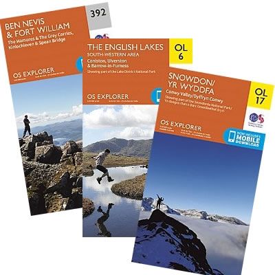
The National 3 Peaks OS Map Pack contains three maps:
Explorer Map 392: Ben Nevis
Outdoor Leisure Map OL6: The English Lakes - South Western Area (Scafell Pike)
Outdoor Leisure Map OL17: Snowdonia
Outdoor Leisure Maps are ideal for all kinds of outdoor activities - from walkers and cyclists to horse riders, climbers and water sports enthusiasts.
Each map now includes a digital version of the map for your smart phone or tablet.
The 1:25,000 scale (4 cm to 1 km - 2Ω inches to 1 mile) maps feature:
Rights-of-way information for England and Wales
Selected tourist information
Access land (on maps of England and Wales)
Picnic areas and viewpoints
National Trail and Recreational Path routes.
Description
The National 3 Peaks OS Map Pack contains three maps:
Explorer Map 392: Ben Nevis
Outdoor Leisure Map OL6: The English Lakes - South Western Area (Scafell Pike)
Outdoor Leisure Map OL17: Snowdonia
Outdoor Leisure Maps are ideal for all kinds of outdoor activities - from walkers and cyclists to horse riders, climbers and water sports enthusiasts.
Each map now includes a digital version of the map for your smart phone or tablet.
The 1:25,000 scale (4 cm to 1 km - 2Ω inches to 1 mile) maps feature:
Rights-of-way information for England and Wales
Selected tourist information
Access land (on maps of England and Wales)
Picnic areas and viewpoints
National Trail and Recreational Path routes.
Explorer Map 392: Ben Nevis
Outdoor Leisure Map OL6: The English Lakes - South Western Area (Scafell Pike)
Outdoor Leisure Map OL17: Snowdonia
Outdoor Leisure Maps are ideal for all kinds of outdoor activities - from walkers and cyclists to horse riders, climbers and water sports enthusiasts.
Each map now includes a digital version of the map for your smart phone or tablet.
The 1:25,000 scale (4 cm to 1 km - 2Ω inches to 1 mile) maps feature:
Rights-of-way information for England and Wales
Selected tourist information
Access land (on maps of England and Wales)
Picnic areas and viewpoints
National Trail and Recreational Path routes.